Introduction
Since version 5.0 OpendTect supports a new way of processing a 2D HorizonCube. The workflow is interactive and operates in regions. A region is defined as a vertical segment bounded by horizons and faults. HorizonCube processing is performed on a line-by-line basis and per region. Next the user interactively correlates HorizonCube segments from region to region over the entire line. This results in a merged HorizonCube in which all segments are correlated and the number of horizons per segment is equal. To process grids of 2D lines the user correlates and merges separately processed HorizonCubes into a final HorizonCube for the grid.
HorizonCube processing for one line is performed in three steps:
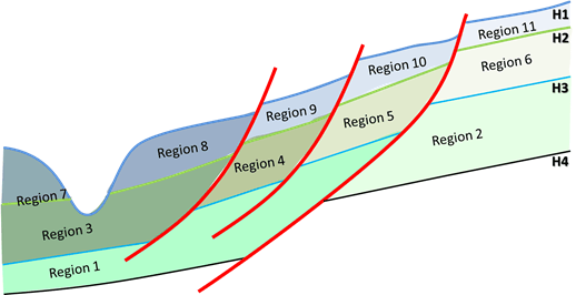
HorizonCube regions are automatically constructed as closed polygons from the given set of horizons and faults. The illustration above shows a set of geological regions that are automatically constructed by the algorithm.
© dGB Beheer B.V. 2002 - 2019