4.3.11.5 GPR - DTZ
Ground penetrating radar offers an accurate solution to mapping the subsurface of the earth. It locates features of interest and subsurface layers in real time. The GPR data visualization and interpretation can be made in OpendTect, which enables the user to import the files made by GSSI Ground Penetrating Radar (GPR) systems in the 'DZT' format. The result is a 2D line in OpendTect.
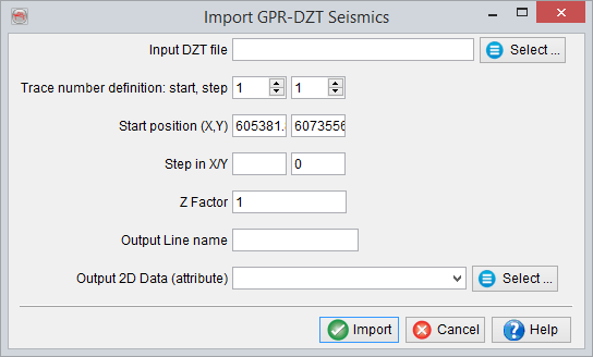
Prior to loading a GPR data, the 2D survey should be setup according to the GPR acquisition setup. The data files are then imported as 2D geometries. The following Import GPR Seismics window allows the user to select one line and import the line according to the given setup. The time stamps or sampling rate in OpendTect is defined in milli-seconds. However, the DZT files are often sampled with nanoseconds sampling rate. To adjusted this, there is an input field available i.e. 'Z factor' that allows re-scaling of Z-axis or time. In order to visualize the data in OpendTect, this factor should be large enough. The remaining parameters i.e. Start X,Y position or X/Y steps could be filled according to the profile location.